

Zahara de la Sierra
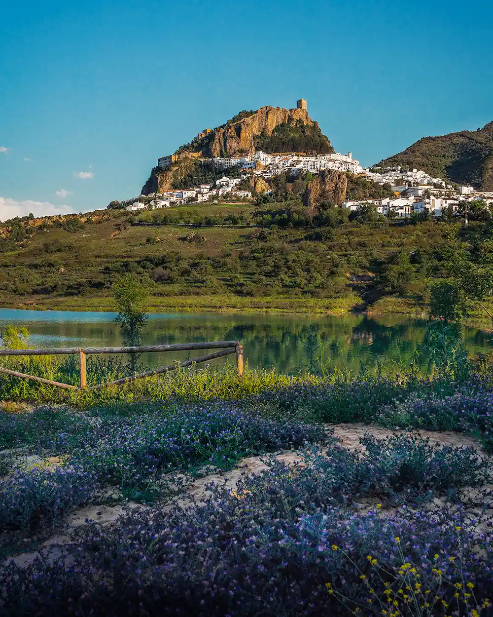
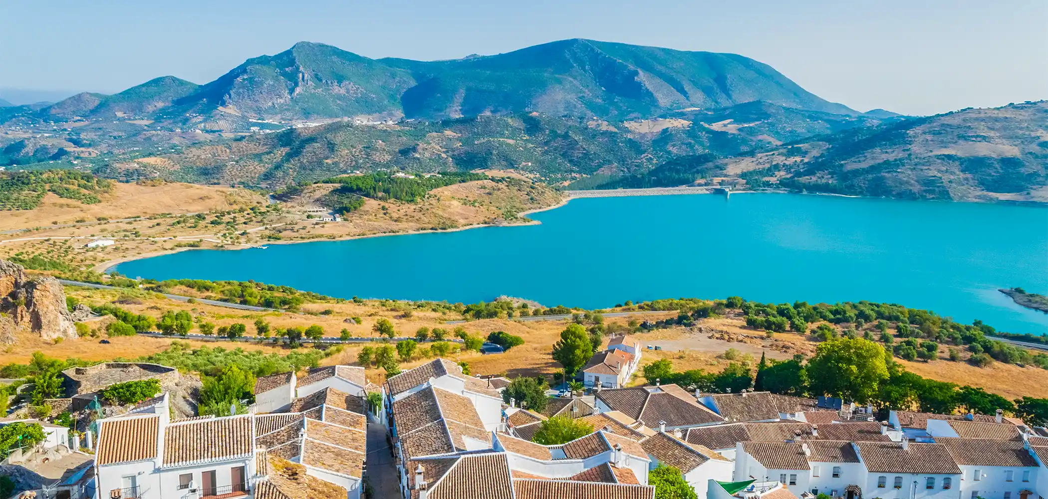
Zahara has one of the most breathtaking settings of any pueblo blanco in Spain. When you first catch sight of it from the approach road—a medieval castle perched impossibly on a rocky crag, white houses tumbling down the hillside, all reflected in the turquoise waters of the reservoir below—you’ll understand why this tiny village stops people in their tracks.
Quick facts About Zahara de la Sierra
- Province: Cádiz (though it sits at the meeting point of three provinces)
- Population: Around 1,500 zahareños
- Altitude: 500-600m (the castle reaches over 1,000m)
- Distance from Ronda: 60km (50 minutes)
- Best for: Views, hiking, photography, disconnecting from modern life
- Time needed: Half day minimum, full day ideal, weekend if you’re hiking
The name “Zahara” comes from the Arabic sahra meaning desert—ironic, considering this is actually one of the wettest spots in Spain thanks to its position in the Sierra de Grazalema Natural Park.
The Crown Jewel: Climbing to the Medieval Castle
Let me be straight with you: this climb is no joke.
When I took my parents visiting from Cádiz, my mother had to stop three times to catch her breath. But every single person who makes it to the top tells me the same thing—it was worth every step.
Tickets & Entry
- Location: Ticket office just inside the Arco de la Villa (the medieval town gate)
- Price: €3.50 per person (as of January 2025)
- Hours: Typically 10:00-18:00 (check locally as they close in bad weather)
- What’s included: Access to the entire medieval complex, Centro de Interpretación, and castle tower
Important weather note: This province of Cádiz is known for fierce winds. I’m from Ronda, so I’m used to wind, but up at the castle it can be extreme. They’ll close the site if conditions are dangerous. Always check before visiting—the Sierra de Grazalema is also one of the wettest places in Spain (yes, in Andalusia!), so rain can roll in fast.
Phase 1: The Steps (10 minutes)
From the ticket turnstile, you start climbing immediately. Hundreds of stone steps zigzag up the hillside. In summer, this can be brutal—you’re fully exposed to the sun. January, when I usually go, is perfect.
Take breaks. Admire the views. Watch the village drop away below you.
Phase 2: Villa Medieval
About halfway up, you reach what was once the main church, now a small interpretation center. There’s historical info about the castle’s construction by the Moors in 1282 and its role defending the Kingdom of Granada. Honestly, when you’re hot and tired, you might not spend long here. But the public toilets outside are very welcome!
Phase 3: The Final Ascent
Another stone path leads upward. Your legs are burning. But keep going.
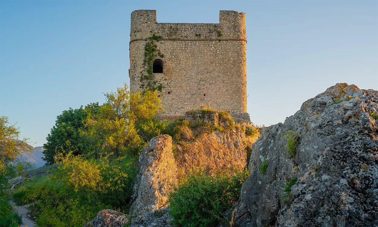
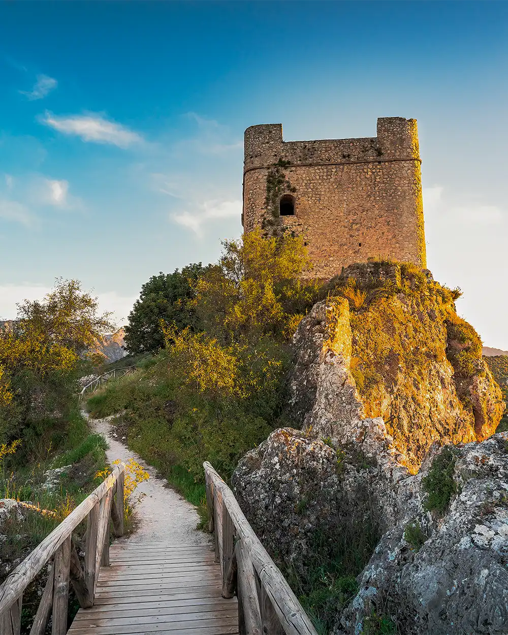
Phase 4: Torre del Homenaje (The Keep)
And then—you’re there. Standing at over 1,000 meters elevation, with three provinces spread out beneath you.
Looking east: the mountains of Málaga province.
Looking west: the plains of Sevilla.
Looking south: Cádiz province, where you stand.
The castle itself is mostly ruined—massive defensive walls, the imposing keep (Torre del Homenaje), remnants of the Nasrid-era fortress. But the strategic importance becomes crystal clear from up here. For centuries, this was the Moorish lookout point, watching for Christian armies approaching from the north.
Walk out onto the ridge in front of the castle. The rock drops away vertically. Looking back, you see how the fortress literally grew from the mountain itself. It’s spectacular.
And it’s windy as hell. Seriously, hold onto your hat. And your phone.
Exploring the Village: A Walking Route
Once you’ve descended from your mountain conquest, the village itself is a dream to wander. Unlike larger towns, Zahara is genuinely small—you can see everything in 1-2 hours at a leisurely pace.
In the Town Hall & Tourist Office you can grab a map showing all eleven miradores (viewpoints) in the village. Yes, eleven. This is a place serious about its views.
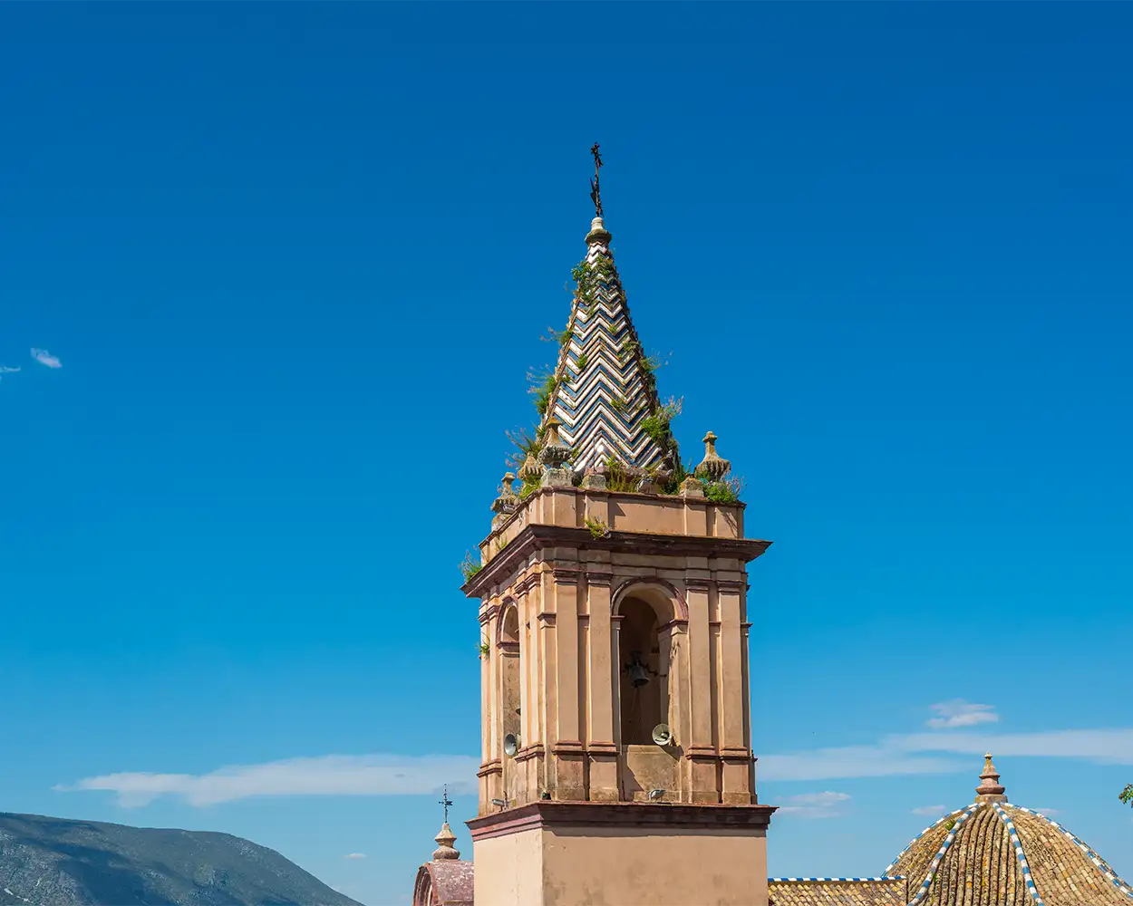
Iglesia de Santa María de la Mesa
Built between 1742-1779, this Baroque beauty is the town’s main church. The exterior is gorgeous—classic Andalusian white with a red-tiled tower visible from everywhere. If you’re lucky enough to catch it open (it wasn’t during my last visit), the 18th-century organ inside is remarkable.
Mirador Tres Provincias (Three Provinces)
This is the big one. From this single spot, you can see Málaga to the east, Sevilla to the west, and Cádiz where you stand. On a clear day, you can even spot the white village of Olvera in the distance. It’s mind-blowing to think that centuries ago, there were no roads here—just mountain passes and trails where merchants and soldiers traveled by donkey and horse between these regions.
Mirador Plaza del Rey
Right next to Plaza Mayor, this terrace gives you sweeping views over the reservoir. Sunset here is magical.
Mirador Alameda de Lepanto
A quiet square with benches and stunning views of the whitewashed houses.
Mirador Boquete
As you walk downhill toward this viewpoint, check out the decorative tiles set into the low walls—Paseo de los Refranes. They’re traditional Spanish proverbs and poems about Zahara. If you read Spanish, they’re charming. If not, they still make for interesting photos.
Where to Eat
Zahara is tiny. In high season (spring through early autumn), you’ll find several restaurants and tapas bars open around the village. In low season—and I’m talking November through March—many close completely.
La Despensa de Zahara
More of a deli/shop than a restaurant, but worth visiting for local products: jamón ibérico, olive oil from nearby mills, regional cheeses, local honey, and those wide-brimmed Andalusian hats (cordobeses). Great for picnic supplies or gifts.
Restaurants around Plaza Mayor
Names change, but there are typically 3-4 places with terraces on the square. Expect traditional dishes:
- Rabo de toro (oxtail stew)
- Sopa de tomate and sopa de espárragos (tomato and asparagus soups, local specialties)
- Grilled meats and local game when in season
- Cuernos (cream-filled pastries shaped like horns) for dessert
How to Get to Zahara from Ronda
By Car (Recommended)
From Ronda, the journey to Zahara is an experience in itself. Take the A-374 toward Arriate, then continue on the A-382. The route winds through the stunning Serranía de Ronda, past cork forests and limestone peaks.
The drive takes about 50 minutes and honestly, you’ll want to pull over multiple times for photos. When you finally round that last bend and see the reservoir appear—Embalse de Zahara-El Gastor, built in 1992—with the castle floating above it, that’s the moment. That’s the shot everyone remembers.
Driving directions:
- Exit Ronda toward Arriate on A-374
- Continue through Serranía de Ronda
- Join A-382 toward El Gastor/Olvera
- Follow signs to Zahara de la Sierra
By Public Transport
I’ll be honest—public transport to Zahara is tricky. Comes runs a bus service between Ronda and Cádiz that stops in Zahara, but services are infrequent and you may need to change in Puerto Serrano. Check the Comes timetable before planning.
For visitors from Málaga or Sevilla without a car, I’d recommend:
- Renting a car (you’ll want one to explore the area anyway)
- Booking a private day trip through companies like Daytrip
- Joining a guided tour that includes multiple pueblos blancos
From Other Major Cities
- From Málaga: 140km via Ronda (2 hours) or via Ardales (1h 45min)
- From Sevilla: 125km via A-375 and A-382 (1h 45min)
- From Cádiz: 120km via Jerez and A-382 (1h 45min)
Natural Wonders Around Zahara
If you’re content with just the castle and village walk, you’re missing half the point of Zahara. This village sits in the heart of the Parque Natural Sierra de Grazalema, one of the most biodiverse and dramatic protected areas in southern Europe.
La Playita (Área Recreativa Arroyomolinos)
Yes, you read that right—Zahara has a beach.
Well, sort of. La Playita is an artificial beach area created along the reservoir shore at Arroyomolinos, about 2km from the village at the base of Monte Prieto mountain. And in summer, it’s absolutely brilliant.
What you’ll find:
- Sandy beach area and swimming zone in the reservoir
- Shaded picnic areas with tables
- Children’s zip-line
- Kayak rentals (from various operators by the water)
- Showers and changing facilities
- Chiringuito (beach bar) serving cold drinks and simple food
Practical details:
- Open: Mid-June through mid-September (approximately)
- Entry fee: €3.50 per person per day
- Parking: Free parking area nearby
- Best time: Weekday mornings to avoid crowds
The water is refreshingly cool—it’s a reservoir, not the coast—but after a morning climbing up to the castle in July, diving into that turquoise water feels like heaven. The kids love it, and honestly, so do I.
Hiking: La Garganta Verde
Now we’re talking about one of the most spectacular hikes in all of Andalusia.
La Garganta Verde (The Green Gorge) is a 5km trail leading down into a massive, 400-meter-deep limestone canyon. The walls tower above you. Griffon vultures circle overhead (and sometimes roost in the caves). Rock formations twist into impossible shapes. It’s the kind of place that makes you understand why people become obsessed with hiking.
Key details:
- Difficulty: Moderate to hard (steep descents, rough terrain)
- Distance: 5km (2.5km down into the gorge, 2.5km back up)
- Time: 3-4 hours round trip
- Permit required: YES—this is crucial!
You cannot just show up and hike. The trail is in a protected area and requires a free permit that must be requested in advance through the Junta de Andalucía’s booking system. In high season, permits can book up weeks ahead.
Get your permit here: Ventanilla del Visitante.
My experience: I’ve attempted this trail twice. The first time, everything was perfect—until we were 10 minutes from the gorge entrance and a massive storm rolled in from the Atlantic. The wind was insane (and I grew up with Cádiz wind, so that’s saying something). We had to turn back. It was the right call—getting caught in that canyon in a storm would have been genuinely dangerous.
The second time, we completed it, and wow. Just wow. The scale of that gorge, the silence broken only by bird calls and wind through the rocks, the sense of being completely disconnected from the modern world—it reminded me of the great mountain gorges of Northern Pakistan (which I consider some of the most beautiful on Earth).
Safety notes:
- Check weather forecasts religiously
- Bring plenty of water (3L per person minimum)
- Wear proper hiking boots—the terrain is rocky and can be slippery
- Start early to avoid afternoon heat
- Don’t go alone if possible
- If conditions deteriorate, turn back
Where to Stay
Zahara isn’t overflowing with accommodation, which is part of its charm. Most options are small rural hotels or apartment rentals.
Hotel Tugasa Arco de la Villa
Built into the old town gate (Arco de la Villa), this is the most atmospheric option. Traditional Andalusian style, some rooms with spectacular views, decent restaurant. The rooftop parking is a bonus.
Hotel Los Tadeos
Countryside style with outdoor pool, peaceful location, good breakfast. About 1km from town center.
Apartments
Many locals rent out apartments through Booking.com and Airbnb. These can be excellent value for families or longer stays, with full kitchens for self-catering.
Staying in Ronda Instead
Many visitors (especially those without car) base themselves in Ronda and visit Zahara as a day trip. Ronda has far more accommodation options, restaurants, and other attractions. It’s a 50-minute drive, making it very doable.
From Ronda, you could easily combine Zahara with Setenil de las Bodegas (the village built into cliffs) for a full day exploring the region.
Where to Park
This is crucial because parking confusion can ruin your visit. Here’s what I do:
Mirador Peñón de la Horca
- Before driving up into town, stop at this viewpoint on your right
- Free parking
- Best panoramic photo opportunity of the entire village
- From here, you can drive up or walk (10-15 minutes uphill)
Arco de la Villa
- Free parking just below the old town gate
- Close to the ticket office for the medieval castle
- Can be full on weekends and holidays
Plaza Mayor area
- Limited street parking around the main square
- Follow the one-way system: enter via Calle Ronda
- Be careful at lunch—restaurant terraces narrow the street
Frequently asked questions
When is the best time to visit Zahara de la Sierra?
Late April through early June or September to mid-October offer the best balance. You’ll get pleasant temperatures (15-25°C), green landscapes, fewer crowds, and everything open. Avoid mid-summer if you’re planning the castle climb—temperatures can hit 35°C+ and you’re fully exposed. Winter (December-February) is beautiful for solitude and clear views, but many restaurants close and the castle may shut in bad weather.
How long should I spend in Zahara de la Sierra?
Half a day minimum to see the castle and village properly. A full day is ideal if you want to relax, enjoy lunch, and explore the viewpoints without rushing. Plan a full weekend if you’re hiking Garganta Verde or spending time at La Playita beach in summer.
Is Zahara de la Sierra windy?
Yes, extremely. Cádiz province is known for strong winds, and at the castle (over 1,000m elevation), it can be intense enough that they close the site for safety. Always check weather conditions before visiting, especially if planning to hike.
Are there restaurants open year-round?
No. In low season (November-March), most restaurants close completely. During a January visit, only one restaurant was open in the entire village. Always call ahead in winter, or bring picnic supplies from Ronda.
Can I swim in the lake?
Yes! La Playita de Zahara (Área Recreativa Arroyomolinos) is an artificial beach open mid-June through mid-September. Entry costs €3.50 per person. The water is cool but refreshing, and there are kayak rentals, picnic areas, and a beach bar.
Is Zahara de la Sierra crowded with tourists?
Not compared to coastal Andalusia or even Ronda. Weekends in high season (April-June, September-October) see more visitors, but it never feels overwhelmed. Midweek or low season, you might have the castle nearly to yourself.
What makes Zahara different from other white villages?
The setting is genuinely dramatic—a medieval Moorish castle at over 1,000m overlooking a turquoise reservoir, surrounded by the mountains of Sierra de Grazalema Natural Park. It sits at the meeting point of three provinces (Cádiz, Málaga, Sevilla), making it historically strategic. Plus, it’s one of the wettest spots in Spain despite being in Andalusia, creating unique green landscapes.